 |
 |
 |
 |
 |
 |
 |
 |
 |
 |
 |
 |
 |
Pliocene Epoch: 5.3-2.6 Million Years Ago
Bruneau Woodpile, Idaho
Bruneau Woodpile: An Unusual Fossil Deposit New evidence indicates this deposit will be moved to the late Miocene. |
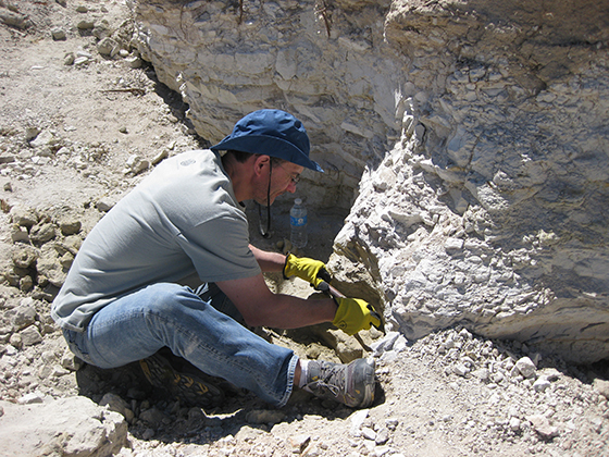
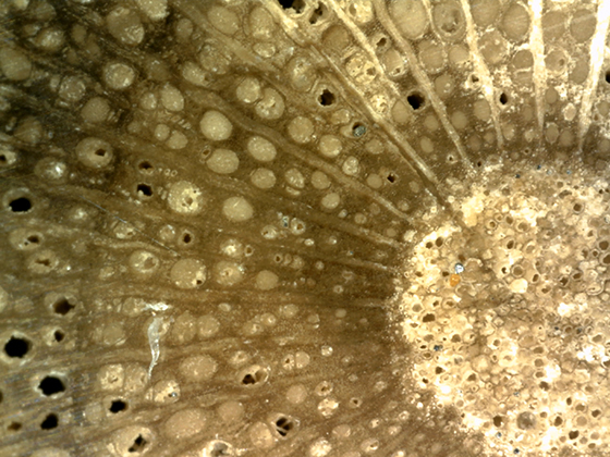
Petrified wood at the Bruneau Woodpile stands in stark contrast to many famous deposits in its mineralization and its abundance of specimens exhibiting a surprising diversity of species. Bruneau petrified wood is described as being mineralized primarily with calcium carbonate CaCO3 and calcium sulfate CaSO4 (Root, 1971, p. 36). Recent analyses performed at the Western Washington University Geology Department using X-ray spectroscopy indicates that fossil wood from the Bruneau Woodpile is actually composed of apatite Ca5(PO4)3(OH,F,Cl) (Mustoe, 2014). If you spend time digging for this phosphate wood at Bruneau you are likely to find several wood types or more among your finds including both hardwoods and conifers. The Bruneau Woodpile lies in unit Ti of the Miocene/Pliocene Idaho Group Sediments (Jenks et al., 1998). Fish fossils collected near the Bruneau Woodpile vicinity are found in the Pliocene-aged Glenns Ferry Formation of the Idaho Group (Smith et al., 1982, p. 522). The Glenns Ferry Formation is an assemblage of lacustrine (lake) and fluvial (river) deposits interbedded with lava flows and ash beds covering several thousand square miles in the Western Snake River Plain (Malde, 1972, p. 7). Starting around 9 million years ago a series of lakes formed and then dried up. Eventually a single enormous lake known as Lake Idaho formed stretching over 200 miles from present day Weiser to Twin Falls. Over a period of 6.5 million years thousands of feet of sediment accumulated within the lake from nearby mountain ranges. Between 2 to 4 million years ago glaciers were melting and Lake Idaho overflowed draining to the west and carving out the deepest canyon in North America known as Hell's Canyon (BLM, 2013). River deposits in the Glenns Ferry Formation representing an ancient flood plain are responsible for the Hagerman Fossil Beds. This national monument is home to over 200 species of fossil plants and animals including sabertooth cats, ground sloths, and mastodons. The site is most famous for fossil of Equus simplicidens, the first true horse and Idaho's state fossil (National Park Service, 2014). It is within the Pliocene lake and river deposits that the Bruneau phosphate wood is found. Success at Bruneau depends on bringing the right tools. We suggest the following: shovels, pickaxe, rock hammers, small crowbars, handheld sledgehammer, and chisels (we found wider chisels the most useful). Chisels are a must! You will notice that people before you have tried to tunnel to extract the wood but patience and hard work pay big dividends. It is best, in our opinion, to prepare an area that is appoximately 6 feet square, which will take at least half a day. Here is what to expect. A shovel will be used to remove soil. A pickaxe will quickley remove layers of shale. You will be happy at this point. |
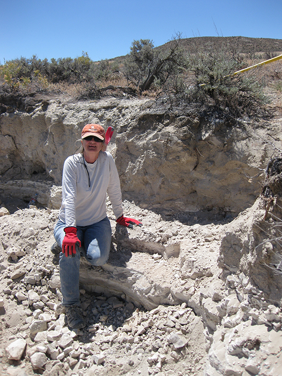 |
| Next, a sandy layer lies on top of the sandstone/siltstone layers. You will be tempted to try and use your pickaxe but it will rebound making only small dents. You can find cracks and weaknesses in the sandstone layers, just keep working them. You will feel despair; however, remember each little bit you remove gets you closer to the fossil wood. Once you remove these layers you will find full rounds and river tumbled specimens cemented in a sandy matrix. |
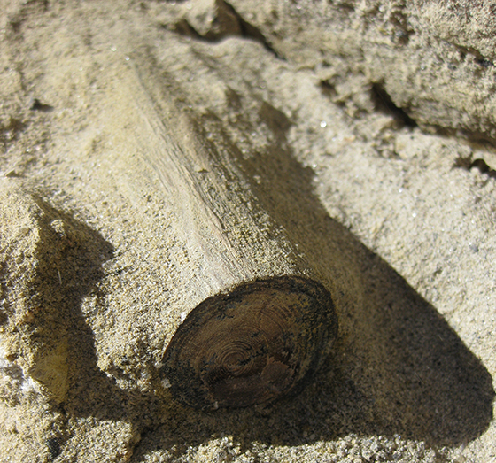 |
| You can work the rest of the day and the next day removing these fossil wood specimens. The sharp end of a rock hammer and tools to gently pry up the fossils are most helpful in the wood layer, which is about 6 inches in thickness. |
 |
Directions: The Bruneau Woodpile is located in south central Idaho close to Interstate 80. From the town of Bruneau travel 1 to 2 miles west on Highway 78 until you reach the junction of Highway 78 and Highway 51. Turn south on Highway 51 and travel 9.1 miles until you pass mile marker 61. On the left is a gravel road that takes you into the dig area. Walk around a little and you will find outcrops where others have dug. GPS coordinates (lat, long) 42°45'49.37"N, 115°53'29.45"W (Bruneau Woodpile, 2010). Click on Bruneau for a printable version of this article. |
 |
Bibliography |
Hoadley, B.R. (1990). Identifying Wood: Accurate Results with Simple Tools. Newton, Connecticut: Taunton Books & Videos. Jenks M.D., Bonnichsen, B., & Godchaux, M.M. (1998). Geologic Map of the Grand View-Bruneau Area, Owyhee County, Idaho. Idaho Geologic Survey Technical Report 98-1. Malde, H.E. (1972). Stratigraphy of the Glenns Ferry Formation from Hammett to Hagerman, Idaho. USGS Bulletin: 1331-D. National Park Service (2014). Explore a fossiliferous Pliocene-aged site! Hagerman Fossil Beds. Root, J.V. (1971). Bruneau Wood. Gems and Minerals, pp. 36 & 37. Scott (2010). Burneau Woodpile. Finding Rocks. Smith, G.R., Swirydczuk, K. Kimmel, P.G., & Wilkinson, B.H. (1982). Fish Biostratigraphy of Late Miocene to Pleistocene Sediments of the Western Snake River Plain, Idaho. In Bonnichsen B. & Breckenridge, R.M. [Eds.]. Cenozoic Geology of Idaho: Idaho Bureau of Mines and Geology Bulletin 26, p. 519-541. |